Captain Alatriste's Madrid
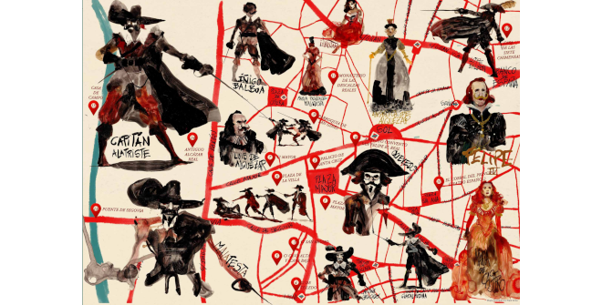
Captain Alatriste’s Spain was a harsh, violent and dark Spain. Yet it was also a country where many great things were happening. In a small area of Madrid, for instance, one could find the greatest concentration of literary talent in the world, for the likes of Lope, Calderón, Cervantes, Quevedo, Góngora and Ruiz de Alarcón, to name a few, all lived in the same neighbourhood. Today, when we walk these streets, take Calle del León or Calle de Cervantes (back then known as Calle de Francos) for example, or pass by the Convent of Las Trinitarias, we may stop and think, “In times past, Cervantes and Lope also walked on these very roads. They once stopped right here, exactly where I’m standing, and looked up at the same building I’m standing in front of today.” It’s incredible to think we are gazing upon the same city as they once did.
In 1656, Philip IV of Spain commissioned Pedro Teixeira to design a very precise, reliable map of Madrid that accurately depicted the city’s physiognomy. It was this map I used when writing Captain Alatriste. Its large-scale detailed representation in three dimensions is truly impressive. In fact, it’s so well done that, if you look closely, you can see every house in the city, its height, whether or not it had a garden and if it did, whether it had a fountain or trees. I pored over Teixeira’s map to help me set the scenes. That way, when I was describing an ambush on say Calle Barquillo, by the House of the Seven Chimneys, I could pinpoint the exact corner where it would take place. I knew where the lamppost stood, the spot where one character would wait and from which another would flee.
For me, Alatriste is much more than a book or a novel. It’s a window into a world that disappeared long ago, whose streets – thanks to literature – we can now walk again.
Among many other works, Arturo Pérez-Reverte (Cartagena, 1951) is the author of the most successful series of novels in contemporary Spanish literature, The Adventures of Captain Alatriste, which celebrated its 25th anniversary in 2021.
Text taken from the book Viaje a los escenarios del capitán Alatriste, by Juan Eslava Galán (El País-Aguilar, 2006), except for the description of Calle Toledo.
Illustrations: Raúl Pérez
- Download the map (1.5 MB) (EN)


